‘Unplanned Urbanisation Has Affected Bengaluru’s Vegetation Cover And Water Bodies’
Rainwater harvesting is the best option as it meets 70% of water demand, says Indian Institute of Science environmental scientist and wetland expert, T.V Ramachandra

Bengaluru: Even before the peak of summer, India’s IT hub Bengaluru has been reeling under a water crisis for over a month, with borewells drying up and residents complaining of exploitative prices for water tankers.
Despite a government order capping water tanker prices based on distance and quantity, there are reports of non-compliance. Nearly half of the city’s water needs are met by groundwater. The city’s water needs are short by 500 million litres per day, said the state’s chief minister Siddaramaiah.
Bengaluru was dependent on a network of lakes and channels to handle water surpluses and store water. But in half a century since 1973, the city has lost 88% vegetation cover and 79% of water bodies, says T.V. Ramachandra, environmental scientist and coordinator, Energy and Wetlands Research Group, at the Centre for Ecological Sciences, Indian Institute of Science (IISc), Bengaluru.
His research team’s study and analysis show that between 1973 and 2022, forest cover fell from 28% to under 1% while built-up area increased from 8% to 87%.
Land-use changes in Bengaluru city, 1973-2022
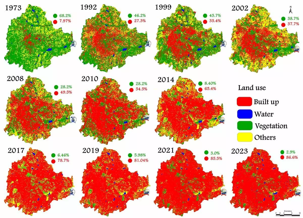
Source: Indian Institute of Science, Bengaluru paper in Advances in Environmental and Engineering Research
“Converting porous landscapes with vegetation and waterbodies to paved surfaces has led to a lack of groundwater recharge coupled with the overexploitation of groundwater due to the mushrooming of high-rise buildings throughout the city,” he said.
In an interview, Ramachandra talks about the need to map aquifers, rainwater harvesting, reusing treated wastewater, and rejuvenating lakes and water bodies, and why cities have to become resilient to climate change.
Edited excerpts:
Bengaluru has been witnessing acute water distress over the last month, reminding residents to manage water resources sustainably. How has unplanned urban growth contributed to water stress, to a city that sits at an elevation of 900 m above sea level?
The city landscape has witnessed 1055% increase in paved surfaces (concrete area) with the loss of 88% vegetation cover and 79% of waterbodies in the five decades between 1973 and 2023 with the unplanned urbanisation, due to lack of coordinated good governance or fragmented governance with too many inefficient and corrupt para-state agencies
As per the estimate, 45% of the city's water requirement is met through groundwater. Converting porous landscapes with vegetation and waterbodies to paved surfaces has led to a lack of groundwater recharge coupled with the overexploitation of groundwater due to the mushrooming of high-rise buildings throughout the city. Relaxation of the floor-area ratio--a ratio of usable area of the building to the land area upon which the building stands--without taking into account infrastructure and natural resources availability has aggravated the problem.
The city landscape is undulating and broadly, there are three major watersheds. Rivers passing in these watersheds were transformed to stagnant water bodies (by constructing bunds at regular intervals) to meet the irrigation and domestic water demand. The current spatial extent of Bengaluru is 740 sq km where we have 193 water bodies. During 1800, we had 1,452 interconnected water bodies and the green cover was more than 80%. Due to this we had a salubrious climate, with temperatures of 14 to 16°C during summer in May and for a few days in December 0°C. During that time, there were reports of growing apples at [Bengaluru] Palace orchards. Today, with the unplanned urbanisation, Bengaluru is unliveable with the scarcity of oxygen and water.
It is estimated that 1,372 MLD of groundwater is utilised in the city. Groundwater caters to nearly half of the city’s water needs while rest is provided by Cauvery water at an estimated daily pumping cost of Rs 3 crore. Government data show that all Bengaluru urban groundwater assessment units are overexploited. A WELL Labs report indicates that current real losses from water supply pipelines stands at 448 MLD, which directly recharges groundwater. How can groundwater resources be managed and monitored better? With the depleted water bodies, what are alternatives to recharge groundwater?
Yes, 45% of the city's water demand is met from groundwater sources. Lack of recharging due to paved surfaces (extent of more than 85%), removal of water bodies, which are a lifeline of the city, coupled with overexploitation due to unrealistic urbanisation has contributed significantly to the decline in groundwater table.
To manage groundwater, we need to (i) map aquifers and underground drainage network using advanced technologies; (ii) assess the carrying capacity of the region before planning further development; (iii) keep landscape porous by maintaining a minimum of 33% green cover; and rejuvenation and maintaining lakes by desilting lakes at regular intervals
In our study [of a Bengaluru locality] we found that groundwater [that was available] at 100 feet when the lake was present, was reduced to 600 feet in six years of removal of the lake. And today after 23 years, in that locality, residents have dug borewells up to a depth 1,800 feet, and there is no water. This highlights the linkage of surface water bodies with groundwater resources.
Sarakki lake in Bangalore south was rejuvenated about three years ago. After rejuvenation, within a year, the groundwater table improved by 300 feet. With most parts of the city reeling under severe water crisis, the improved groundwater table and the lake full of water, [it] is moderating microclimate evident from the pleasant climate (and temperature is lower by 2°C).
Your Bangalore Lakes Information System (BLiS) analysis shows that lakes in Bengaluru provide ecosystem value of Rs 365 crore a year. Can you expand on your findings and importance of lake rejuvenation and protection for the city?
Comparative assessment of ecosystem services of well managed lakes with polluted lakes certainly provide insights of the benefits of involving all local stakeholders for managing lake rejuvenation.
Lakes provide provisioning services such as fish, fuel, fodder, water for agriculture, washing clothes, etc. Our study in Rachenahalli and Jakkur lakes provides provisioning services of Rs 10,500 per hectare per day, while polluted lakes (like Amruthahalli lake) services are about Rs 20 per hectare per day. This highlights the vital role played by lakes in sustaining local livelihood (fishing community, farmers, etc.) Apart from these, quantification of all ecosystem services (provisioning, regulating and cultural services), highlights that the total ecosystem supply value amounts to Rs 10 lakh per hectare per year and indicates that wetlands/lakes are one of the most productive ecosystems.
Historically, the city’s water system was built on water tanks, wells and rainwater harvesting which fell into disuse as piped water took precedence. There are at least eight custodians for Bengaluru’s various lakes including BBMP, Ministry of Defence, zilla panchayat, BWSSB etc. How has urban water governance been different or unique in Bengaluru's development?
I agree, colonial rulers killed decentralised water harvesting structures deliberately by transferring water through pipes, which benefited them. Unfortunately, even after Independence, the colonial mindset prevails in bureaucrats , which is evident from the mismanagement of decentralised water harvesting structures.
We need to revive the Karnataka Lake Development Conservation Act and ensure that lakes are managed prudently by an independent agency. Handing over lakes to KTCDA [Karnataka Tank Conservation and Development Authority] was the biggest blunder as minor irrigation [department] is loaded with civil engineers incapable of managing lakes. Lack of clarity with too many custodians is the reason for encroachment and eventual disappearance of lakes. We need to have effective decentralised governance by integrating executive functional aspects (spread across too many para-state agencies) by taking advantage of recent developments in science and technology (geoinformatics with artificial intelligence and machine learning).
Your paper recommends “planned urbanisation and decongestion of the region by shifting large-scale industries”. Given that the city has under 3% vegetation and loss of lakes and water quality issues compared to 87% built area, how can current problems be reversed? Can you suggest interventions to sustain existing groundwater?
The city receives annual rainfall of 700-850 mm, which amounts to 15 Thousand Million Cubic feet (TMC). Water demand in the city is 18 TMC (45% met by groundwater), which means we can meet 70% of our demand through rainwater harvesting--through rooftop harvesting at individual household level and at the community level by rejuvenating lakes through desilting. This will enhance water storage capacity of the lake to store rainwater and facilitate groundwater recharge.
If the city uses 18 TMC of water, there is 18 TMC of wastewater. If we adopt a nature-based solution through constructed wetland and algal ponds (as in Jakkur lake), then we will have 16 TMC of treated water. This means the city will have 31 TMC of water, which is the sustainable solution and the city will have surplus water.
The city landscape has witnessed unplanned irresponsible urbanisation beyond the carrying capacity of the region and is now evident from acute water scarcity and lower oxygen levels. Now is the time (i) to decongest the city by shifting major industries to other districts so that we will have holistic growth in the state; (ii) should not allow any growth till the carrying capacity of the region is assessed; (iii) rejuvenate all lakes to retain rainwater; and (iv) treat wastewater (household) to the tertiary level through nature-based solutions via constructed wetland and algal pond ( Jakkur lake, which is working satisfactorily since 2010).
How effective has rainwater harvesting been, without a sustained campaign by the government, in a city that is expected to see more vegetation loss and increased built area?
Rainwater harvesting is the best option as it meets 70% of water demand. Its success depends on all stakeholders making sincere efforts and actively promoting the endeavour. Local organisations and water warriors have been struggling to bring awareness among the public. But, poor environment literacy in Bengaluru seems to be the main reason for the poor environmental conditions. The only option is to decongest the city and stop further growth till the assessment of the carrying capacity of the region.
The government should constitute a think-tank of domain experts to plan the liveable city. We need to promote informed decision-making through state-of-the-art expert systems similar to Bangalore Urban Information System and Bangalore Lakes Information System in the planning wing of the government.
Aquifer Mapping and Management Programme (NAQUIM) is reported to have covered all targeted areas for aquifer mapping in the state. One of the aims of NAQUIM is groundwater management plans with community participation. Your comments on the scheme and how it must be utilised to inform communities in urban planning?
NAQUIM data seems to be at a macro level. We need data at a micro level for taluk or village panchayat level. For a decision maker or common person, they need to know the quantity or stock that they can use. Groundwater is a dynamic phenomenon and data must be updated and made available regularly. We cannot think of groundwater only when there is a crisis. It is not difficult to make data available by using technology and information. We need to plan for a spatial decision support system taking advantage of the available big spatial data with artificial intelligence and machine learning so that we can visualise groundwater dynamics at regular interval at micro level similar to Western Ghats Spatial Decision Support System (WGSDSS)
The Union government should facilitate inventorying, mapping and monitoring activities, and data should be managed at the regional level. For example, groundwater mapping is needed [across states] for a scheme like Har Ghar Jal which aims to provide household tap water supply. Naturally, communities should be involved because it is a complex and massive task.
Arrogance of the current decision-makers, who only opt for ad hoc or reactionary path to crisis [resolution] rather than prudent planning based on the data, is the main hindrance for sustainable planning. We need to make bureaucracy accountable for the failing liveable status of the city. For example, Bangalore Water Supply and Sewerage Board should be held accountable for not treating wastewater, polluting lakes (through sustained discharge of untreated or partially treated wastewater), mismanaging storm water drains (for transferring city’s wastewater) and mismanagement of the city's water..
We need to have subject experts in civil services for crucial assignments related to natural resources management rather than having only IAS cadre at all levels of the administration.
In 2018, Cape Town--impacted by drought--averted Day Zero by restricting demand and regular communication with residents by the government. The same year, Shimla also faced a water crisis for different reasons, but impacting residents and the tourism industry. While climate change-related factors like less rainfall and drought are expected in the future, how resilient are metropolises like Bengaluru or Mumbai that attract large numbers of migrants across class groups?
We need to ensure climate resilient systems to avert the impending threat of changes in the climate. Water scarcity would become more acute with changes in the climate including decline in rainfall, high-intensity rainfall, and increase in temperature. Decision makers should opt for happiness indices as the sign of development or green GDP (by accounting for ecosystem degradation cost) than blindly follow the erroneous economic metric like GDP.
We need to opt for sustainable options--such as rainwater harvesting, prudent management of water bodies, tertiary treatment of domestic wastewater through nature-based solutions, ensuring zero discharge by industries (making industries accountable for polluting lakes, land and the environment), maintaining green cover (or at least mini forest of 2 hectares in each ward), ensuring parks in each ward for recreation.
This can happen only when we have environmentally literate decision makers. Hence, we need to promote environment education at all levels to sensitise youth, [the] future decision makers with adequate and requisite knowledge for prudent management of natural resources. We need to wake up and manage natural resources prudently, otherwise all of us will pay heavy price with Day Zero conditions soon.
We welcome feedback. Please write to respond@indiaspend.org. We reserve the right to edit responses for language and grammar.